From Rev War Soldiers to Gliders to Gun & Rod Clubs:
The Transition on Schley Mountain
There is no well-documented evidence of a formal, dedicated police or public shooting range in the “The Hills” development itself. But we’re hoping that the locals will come forward and share what they know about shooting sports on Schley Mountain in Bernards and Bedminster Township from the 1950s to the 1980s.
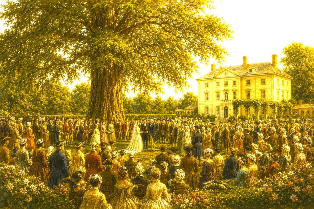
We have to start with the elephant in the room: the development of The Hills. In a relatively short time, this large-scale residential project transformed the Schley Mountain area of the Somerset Hills from a rugged, open landscape into a planned community. Roads replaced old access paths, wooded tracts were carved into lots, and the quiet isolation that once defined the ridge largely disappeared. In doing so, The Hills did more than reshape the land. It obscured much of the layered history that had unfolded there for generations.
Long before that transformation, before gliders rose over Schley Mountain or gun clubs echoed across its ridges, the land along the backside of the Second Watchung Mountain carried a far older and deeper story. Near Pigtail Mountain and the grounds of what became the Pluckemin Artillery Park, this landscape once formed part of a Revolutionary War military complex where Continental Army artillery units trained and encamped during the winter of 1778 to 1779.
Even earlier, these same ridgelines were part of the Native American movement and settlement, with burial grounds and travel routes woven into the terrain. What appears today as a quiet wooded space was once a place of constant activity, layered use, and strategic importance, setting the stage for every chapter that followed.
We have already provided great stories on the history of Pigtail Mountain, the Pluckemin Artillery, and America’s first military training academy, all part of the historic 2nd Watchung Mountain. But now we turn to more modern times… the mid-1900s.
Schley Mountain
Long before subdivisions climbed the hills of Liberty Corner, the ridge known as open land, long sightlines, and quiet isolation defined Schley Mountain. In the 1930s, it was a place of lift and flight, where gliders rode the air currents above Somerset County in the era of early civilian aviation. By the 1960s, that same landscape had taken on a very different character.

In the late 1800s, Grant Schley quietly set the stage for everything that would follow on the ridges above Liberty Corner. A New York financier, Schley began acquiring large tracts of land across Bernards and Bedminster Townships in the 1880s, eventually assembling thousands of acres centered around his estate, Froh Heim, in what became Far Hills. His holdings stretched across the Second Watchung Mountain, including the ridgeline that would later carry his name. What Schley created was not just a country home, but a vast, controlled landscape of farms, woodlands, and hunting grounds. For decades, this land remained open, uninterrupted, and largely untouched by development.

That decision to keep the land open had lasting consequences. After Schley’s death, the estate slowly began to break apart, but the terrain itself remained intact well into the mid-20th century. Those same wide ridgelines and open fields that once served a private estate became ideal for new forms of recreation. First came the gliders of the 1930s, riding the air currents along the mountain. Then came the rod-and-gun clubs, drawn to the same isolation and space. Long before The Hills reshaped the area, the land itself was already writing the story of Schley Mountain through the choices made decades earlier.
Schley Glider Field
In the 1930s, the open ridgeline of Schley Mountain was home to Schley Field, a grass glider and soaring site where pilots took advantage of steady ridge lift along the Second Watchung Mountain. For a brief period, the quiet hills above Liberty Corner became part of the early American soaring movement before the activity faded by the early 1940s.

As aviation faded and large tracts of undeveloped land remained, a new form of recreation emerged across the hills. Private rod-and-gun clubs began to appear, taking advantage of the same isolation and open terrain that had once made the area ideal for soaring. For a time, these clubs fit naturally into a rural environment. But as Bernards Township and the surrounding Somerset Hills began to shift toward residential development, tensions grew. What had once been remote became adjacent, and long-accepted uses of the land came under scrutiny.
Basking Ridge Gun Club
A Glimpse into Basking Ridge During World War II
Recently uncovered was this original booklet containing the bylaws of the Basking Ridge Gun Club, adopted on January 4, 1943. Though only nine pages long, the booklet provides a fascinating snapshot of life in Basking Ridge during the Second World War.
Printed in a small red paper-covered booklet, the bylaws governed every aspect of club operations, from membership requirements and annual dues to meeting procedures, hunting regulations, and disciplinary actions. At the time, membership was limited to just 35 active members. New members paid a $10 initiation fee and $10 in annual dues, while guests were charged $5 per day for hunting privileges after an initial waiting period.
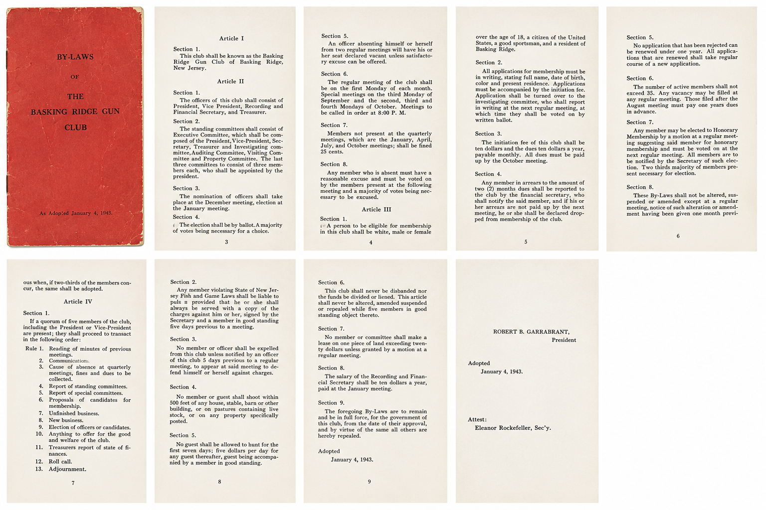
The booklet also reveals the social customs and attitudes of the era. Membership was restricted to residents of Basking Ridge who were over 18 years of age, citizens of the United States, and considered “good sportsmen.” The bylaws further specified that members be white, a reminder that many organizations in the United States maintained racial restrictions during this period.
Meetings were held on the first Monday of each month at 8:00 p.m., with additional meetings scheduled during hunting season. Members who missed quarterly meetings without an approved excuse could be fined twenty-five cents. The club maintained formal committees, election procedures, and disciplinary processes, reflecting the structure and seriousness of many civic and sporting organizations of the time.
The booklet was adopted on January 4, 1943, and signed by President Robert B. Garrabrant and Secretary Eleanor Rockefeller. Handwritten notes and amendments found throughout the booklet suggest that it remained in use for many years after its adoption.
Today, this small booklet serves as a rare surviving record of one of Basking Ridge’s local organizations and offers a valuable glimpse into the community, customs, and sporting traditions of Somerset County more than eighty years ago.
Document Information
Title: By-Laws of the Basking Ridge Gun Club
Location: Basking Ridge, New Jersey
Adopted: January 4, 1943
President: Robert B. Garrabrant
Secretary: Eleanor Rockefeller
Format: Printed booklet with paper covers and stapled binding
The Good Rod and Gun Club — Mt Airy Road, Bernards Township
The Good Rod and Gun Club operated along Mt Airy Road on Schley Mountain, on land that appears to have been leased rather than municipally owned. Like many clubs of the period, it offered recreational shooting, including skeet and target practice,e and relied on the natural buffer of large, undeveloped acreage. By 1965, however, the surrounding area was beginning to change.
Residents living along Mt Prospect Road, including Michael Roscoe and his wife, raised formal concerns about safety, noise, and behavior. Roscoe testified before the Bernards Township Committee that he had personally removed multiple slugs embedded in an outbuilding on his property, which included a pond and stood directly adjacent to the club. He believed the shots originated from the direction of the range.
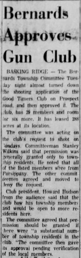
Mrs. Roscoe reported additional concerns, including verbal harassment and obscene language directed at her by individuals associated with the club. Together, their testimony helped shift the issue from a nuisance to a matter of public safety. A petition signed by 46 residents led to a formal hearing. Following deliberation, the Township Committee denied permission for Sunday shooting, marking a significant moment in how local officials addressed legacy rural uses as residential development expanded.
Geographically, the club was located within the broader Schley Mountain area, likely on land that had once been part of, or adjacent to, the earlier Schley Field glider site. While not directly connected to the aviation operation, the reuse of the same open ridge reflects a broader pattern of land transition.
High Metal Gun Club — Liberty Corner Area (Local Recollection)
Less formally documented but preserved through local memory, the High Metal Gun Club occupied land in the Liberty Corner area that extended across what are now developed residential properties. Residents who grew up in the area recall large wooded tracts, informal shooting practices, and frequent tensions between club members and nearby families. Accounts describe birds being released from crates and shot as they took flight, along with reports of verbal confrontations and unsafe conditions.
One recollection places the club near properties owned by the Congdon and Roscoe families, as well as the residence of Bernards Township police chief Bob Moore Sr. The area included features such as a pond, a road, and an abandoned farmhouse, reinforcing the landscape’s rural, lightly developed character at the time.
While these accounts are anecdotal, they align with the broader pattern of mid-century recreational use on large, undeveloped parcels that later became residential neighborhoods.
High Meadows Gun Club
The High Meadows Gun Club represents a later phase of this same pattern, remaining active into the 1970s as development pressures intensified. Also located in the Liberty Corner, Bedminster, and Pluckemin areas, the club drew membership from residents, including individuals connected to the Liberty Corner Fire Company and the Bernards Township Police.
Former residents recall that the club maintained a smaller, more organized membership base in its later years. However, as large-scale residential projects such as The Hills began to reshape the area, the club’s viability declined.
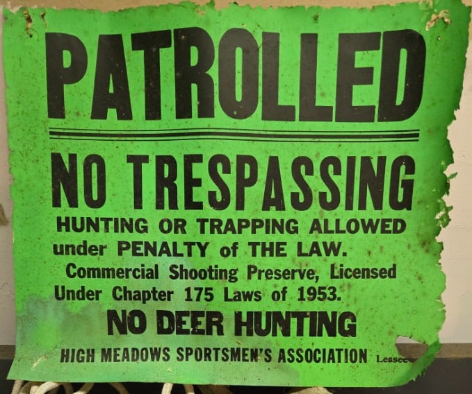
Membership decreased, new enrollment slowed, and the club ultimately ceased operations as development advanced. Its closure reflects the final stage of a broader regional shift, where recreational land uses gave way to suburban expansion.
Those Hills Just Kept On Changing
The history of these clubs is tied directly to the land itself. Schley Mountain began as a place of open-air experimentation, where gliders once lifted off from wide, unobstructed fields. It later became a landscape of hunting and shooting, where isolation enabled recreational activities that required space and distance.
By the late 20th century, that same land had been transformed again, into residential neighborhoods, roads, and planned communities. Each phase left its mark, but none remained permanent. What connects them all is the terrain itself. The same ridge that once carried gliders, then echoed with gunfire, now supports homes and families. The story is not just about what was built there, but about how each generation used the land differently, and how those uses eventually gave way to the next.
We continue digging. Keep sending in those clues!


When I moved to Martinsville section of Bridgewater 44 yrs. ago, the western side of Shley Mtn. was a huge field of standing corn now occupied by the Kings / Shopping Center. Before that the “Red Ball Hunting Club” had Shley Mtn. posted for quite a few years until development of “The Hills” began.
My Grandfather, Boyd Happe, was a proud member. Raised pheasants on Prospect behind 148 Maple. Those houses had trouble with landscaping for many years. Evidently, pheasant crap isn’t great for growing anything.