
Washington Didn’t Build His Fortress. New Jersey Did.
So we start by coining a phrase, one that defines what we think Washington knew all along. A geological fortress is not an artificial fort of stone walls, towers, and cannon. It is a naturally defensible landscape whose mountains, rivers, valleys, cliffs, and narrow passages provide many of the same military advantages. In northern New Jersey, the Watchung Mountains became George Washington’s geological fortress. Known historically as the “Bulwark that Saved a Nation” for shielding George Washington’s troops, the ridges today provide vital parks, local watersheds, and scenic views.

The name is derived from the American Native Lenape name for them, Wach Unks (High Hills). In the 18th century, the Euro-American settlers also called them the Blue Mountains or Blue Hills. The Watchungs formed three long, roughly parallel ridges running across northern New Jersey. Together, they created successive natural barriers between the British strongholds around New York, Newark and New Brunswick and Washington’s principal military positions at Middlebrook, Morristown and the surrounding countryside. An attacking Army could not simply march directly toward Washington. It had to locate and pass through one of the limited gaps in the mountains while moving men, horses, artillery and supply wagons along narrow roads that could be watched and defended.

From commanding elevations such as Washington Rock and the heights above Middlebrook, American lookouts could observe British activity across the broad plains toward New Brunswick, Perth Amboy, and the approaches to New York. Washington could receive warning of an enemy movement, reposition his troops behind the ridges, or descend from the mountains to threaten exposed British columns.

The fortress provided Washington with four major strategic advantages:
- Protection: The ridges shielded the Continental Army from a sudden large-scale British attack.
- Observation: Mountain lookouts offered extensive views across the British-controlled eastern plains.
- Controlled access: Gaps such as Hobart Gap became natural gateways through which an approaching Army had to pass.
- Freedom of movement: Roads behind and along the ridges allowed Washington to shift troops while the British struggled to determine where he would appear next.
The Raritan River strengthened the southern face of this natural defense. At the same time, the valleys, streams, wooded slopes, and wetlands surrounding the Watchungs further restricted the movement of artillery and supply wagons. Middlebrook guarded the southern entrance to the fortress. Morristown sat securely behind its interior ridges. Hobart Gap protected an important eastern approach.

Washington did not build this fortress. He recognized it. His achievement was understanding how New Jersey’s terrain could compensate for an Army that was frequently outnumbered, poorly supplied, and unable to risk destruction in one decisive Battle. The British might control New York City and portions of New Jersey’s coastal plain. Still, Washington controlled the heights—and from those heights, he could watch, withdraw, reposition, and strike.
Washington’s Geological Fortress was the interconnected system of Watchung ridges, river barriers, mountain gaps and protected valleys that allowed the Continental Army to defend northern New Jersey while continually threatening the British positions below.

How Nature Built Washington’s Fortress
Washington’s fortress foundations are actually approximately 200 million years old, formed when enormous lava flows cooled into hard basalt. Over time, softer surrounding rock eroded, leaving the three roughly parallel Watchung ridges.
When the ice age and the Wisconsin Ice Sheet reached northern New Jersey about 25,000 to 20,000 years ago, it reshaped the landscape around those ancient mountains. Glaciers scraped the exposed rock, redirected streams, and deposited great quantities of stone, gravel, sand, and clay. The ice did not build Washington’s mountain walls, but it helped create the difficult approaches that strengthened them.
One of the Ice Age’s most significant legacies was Glacial Lake Passaic. Trapped by ice and glacial debris, its waters spread across the basin between the Highlands and the Watchung Mountains, covering parts of present-day Morris, Somerset, and Union counties. When the lake finally drained, it left behind dense clay soils, marshes, and wetlands. The Great Swamp remains one of its most visible surviving remnants.

By Washington’s time, these swamps and soft lowlands presented serious obstacles to troops, artillery, and supply wagons. They forced armies toward the region’s limited roads and mountain passes.
Rivers and streams cut openings through the Watchung Mountains, creating strategically important gateways. Hobart Gap provided a major approach toward Chatham and Morristown. The Raritan River strengthened Washington’s southern defenses at Middlebrook, while the Passaic and its tributaries obstructed the northern and eastern approaches. Bridges and fords became critical military control points.

Also check out the New Jersey Geology report.
Melting glaciers also deposited large quantities of sand and gravel. These deposits created sandy plains, gravel terraces, and the materials later excavated from the region’s numerous sandpits. Soft sand could impede wagons, while firmer gravel deposits helped determine where usable roads developed.
Washington’s geological fortress was therefore built in stages. Ancient lava created the three mountain ridges. Erosion exposed their hard basalt walls. Rivers cut a limited number of gateways, and the Ice Age added swamps, waterways, sand, and difficult lowlands.

The result was an interconnected defensive landscape: mountains for protection and observation, gaps that restricted enemy movement, rivers that controlled crossings, and former glacial wetlands that made large-scale attack extremely difficult. Nature spent millions of years constructing the fortress that Washington ultimately learned to command.
Washington Recognizes the Fortress
George Washington did not come to New Jersey looking for mountains. He came looking for survival.

By the opening months of 1777, the Continental Army had endured defeat, retreat, and near collapse. Washington’s victories at Trenton and Princeton had revived the American cause, but the British still possessed the larger Army, superior supplies, and a powerful base in New York City. If Washington risked a conventional battle on the open plains of New Jersey, the Revolution could be destroyed in a single afternoon.
So Washington changed the contest. Instead of trying to overpower the British, he would use New Jersey’s landscape to frustrate them.
Stretching across northern New Jersey were three roughly parallel volcanic ridges known today as the First, Second and Third Watchung Mountains. Between them lay protected valleys, swamps, rivers and narrow passages. From their eastern slopes, an observer could look across miles of open country toward New Brunswick, Perth Amboy, Elizabethtown and the approaches from New York. Behind the ridges were Morristown, the Great Swamp and roads leading farther into the Highlands.

Together, these features formed what we are calling “Washington’s Geological Fortress”.
That phrase above is our modern interpretation, not a term Washington is known to have used. But Washington clearly understood the mountains’ military value. He had trained as a surveyor and possessed an unusually sharp eye for terrain. He studied roads, elevations, river crossings, and mountain passes because these features could compensate for what his Army lacked in numbers.

Lenape Trails That Turned Into Continental Army Routes
Long before Washington’s Army arrived, the Lenape had already identified the most practical routes through Central Jersey’s difficult landscape. Their trails followed river valleys, crossed streams at reliable fords, and passed through the few natural openings in the Watchung ridges.

Colonial settlers gradually widened many of these footpaths into bridle paths and wagon roads. One important corridor ran from New Brunswick through Bound Brook and Somerville toward Pluckemin and Peapack. At the same time, another crossed the Watchungs near present-day Plainfield and followed the upper Passaic toward the Bernardsville area. By the Revolution, these ancient paths had become vital roads connecting farms, mills, villages, and military positions across the Raritan Valley.

Those inherited routes helped make the Middlebrook and Pluckemin encampments practical and defensible. Washington’s troops could occupy the protected ground along the Watchung foothills while supplies moved inland from Trenton, New Brunswick, the Raritan Valley, and the farms to the west. Roads behind the ridges also allowed soldiers, artillery, and messages to move between Middlebrook, Pluckemin, Basking Ridge, Morristown, and the Hudson Highlands with less exposure to British observation.
Washington did not create this transportation network; his Army adapted an older landscape of Lenape trails and colonial roads. The same terrain that determined where Indigenous people traveled ultimately shaped where the Continental Army encamped, how it was supplied, and how Washington operated from behind his geological fortress.
Middlebrook: Washington Takes the High Ground
In May 1777, Washington established his Army at Middlebrook along the First Watchung Mountain. Below him, approximately seven miles away, the main British Army occupied New Brunswick.
From the Watchung heights, Washington could watch the British without allowing them to reach him easily. If they moved toward Philadelphia, he could descend and threaten their flank. If they advanced against his camp, they would have to climb steep ground or force their way through one of the limited mountain passes. If the danger became overwhelming, Washington could withdraw deeper into the Watchung while keeping his Army intact.

On June 17, 1777, Washington described the position in a letter to Benedict Arnold:
“The position here is very strong, and with a little labor, which will be bestowed upon it, will be rendered a great deal more so. The passes in the mountains are for the most part extremely difficult.”
That statement may be the clearest surviving description of Washington’s geological strategy. His confidence rested not simply in the number of soldiers around him, but in the ground beneath them. Washington’s Middlebrook position and letter

British commander General William Howe attempted to lure Washington down from the mountains. Howe moved troops out of New Brunswick, hoping Washington would believe the British were abandoning New Jersey. Washington refused to take the bait. He sent detachments forward but kept the main Army close to the safety of the Watchung Mountains.
Short Hills: The Fortress Saves the Army
The danger came on June 26, 1777. When part of Washington’s force moved too far onto the plains near present-day Edison, Scotch Plains, and Plainfield, Howe suddenly turned and attacked. The resulting Battle of the Short Hills was not an American victory. Lord Stirling’s troops were heavily pressured and forced to withdraw.
But the larger British objective failed. The Americans retreated through the foothills and back toward the Watchung defenses. Howe could strike Washington’s exposed troops, but he could not trap and destroy the Continental Army in its mountain position. The ridges gave Washington room to retreat, reorganize, and live to fight another day.
“His design…was either to bring on a General Engagement upon disadvantageous Terms…or to possess himself of the Heights and passes in the Mountains on our left.”
“It was thought absolutely necessary, that we should move our force from the low Grounds, to occupy the Heights before them, which was effected.”
George Washington to John Hancock, President of the Continental Congress, June 28, 1777, describing the Battle of the Short Hills two days earlier. Washington’s complete letter
This was the essence of his strategy. Washington did not need to win every encounter. He needed to prevent the British from winning the war.
Unable to force a decisive battle in New Jersey, Howe eventually evacuated New Brunswick and sailed most of his Army toward Philadelphia. The British chose the long sea route rather than advancing directly across New Jersey with Washington’s Army threatening them from the mountains.
Morristown Behind the Walls
Middlebrook was only one chamber inside the larger fortress. Morristown sat behind the Watchung ridges, protected by the Great Swamp and accessible through a limited number of mountain gaps. It was close enough to threaten British positions around New York, yet difficult for a large enemy Army to approach without warning.

Washington used Morristown during the winters of 1777 and 1779 to 1780. The surrounding mountains offered protection, timber, observation points, and roads leading toward the Hudson Highlands. The Great Swamp formed an additional obstacle to the south and East.
George Washington to John Hancock, January 7, 1777, explaining his decision to bring the Army to Morristown.
“The commanding ground on the back of Morris Town should be immediately fortified…that it may serve as a retreat in case of necessity.”

George Washington’s General Orders, May 14, 1777, directing the construction of the defensive work later called Fort Nonsense.
“I removed from Middle Brook to Morristown, and from Morristown to the Clove, a narrow passage leading through the Highlands.”

The Army could also move between Morristown, Basking Ridge, Pluckemin, and Middlebrook while remaining largely screened by ridges and valleys. Washington’s headquarters could shift, troops could be dispersed, and supplies could be stored behind multiple natural barriers.
Middlebrook Again:
A Fortress Becomes a Military Academy Campus at Pluckemin
Washington returned to the Middlebrook region for the winter of 1778 to 1779, but the Army was no longer concentrated in one simple camp. Its cantonments stretched across Somerset County. Washington established headquarters at the Wallace House in Somerville. Nathanael Greene was headquartered at the Van Veghten House in Finderne. Lord Stirling occupied the Van Horne House. Baron von Steuben stayed at the Staats House, while Henry Knox and the Continental Artillery occupied the hills around Pluckemin.

The best contemporary quote explaining why Middlebrook was selected for the winter of 1778 to 1779 came from Quartermaster General Nathanael Greene in his recommendation to Washington:
“Middle Brook is situate in a plentyful Country, naturally strong and difficult of access and surrounded with a great plenty of Wood. Great security will also be given to this Camp by the militia of the Country.”
The arrangement placed the Army behind the Raritan River and along the Watchung foothills while controlling roads leading toward Morristown, New Brunswick, Trenton, and the Delaware River. At Pluckemin, Knox constructed an artillery cantonment and military training center. There, the Army repaired equipment, trained artillerymen, and strengthened its professional organization. The geological fortress had become more than a hiding place. It had become a protected military campus from which Washington could rebuild his Army.
Lookouts, Beacons and Early Warning

The Watchungs also gave Washington something nearly as important as protection: information.
Lookouts placed along the ridges could observe British activity across the eastern plains. Washington Rock above Green Brook provided a commanding view toward New Brunswick and the coastal corridor. Lookout points farther North watched the approaches toward Springfield, Elizabethtown, and Newark.
The mountains also supported a wider beacon and communication system. Signal stations could warn of British movements and pass information toward Morristown and the Hudson Highlands. Riders then carried more detailed messages through the protected valleys behind the mountains.


Beacon Marker Fort Nonsense near Bernardsville, New Jersey
Washington’s fortress therefore operated as both a shield and an intelligence network. The British might control New York Harbor and the open country near the coast, but Washington often knew when they were coming.
Springfield: The British Attack and Test the Fortress
The greatest test came in June 1780. British and Hessian forces landed at Elizabethtown Point and advanced through Connecticut Farms, now Union Township. Their ultimate objective was Washington’s Army and supplies around Morristown. To reach them, the invaders needed to penetrate the Watchung barrier through Hobart Gap, the natural opening near present-day Springfield and Millburn.
The fighting on June 7 at Connecticut Farms slowed the advance. Two weeks later, on June 23, approximately 6,000 British, Hessian, and Loyalist troops returned. They pushed toward Springfield along routes converging on the entrance to Hobart Gap. Continental troops commanded by Nathanael Greene and a rapidly growing force of New Jersey militia opposed them. Connecticut Farms and Springfield campaign
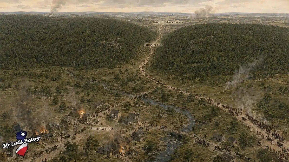
The British burned much of Springfield, but they failed to break through the gap. American resistance, difficult terrain, and the threat of Washington’s main Army gathering behind the mountains made the advance increasingly dangerous. The British withdrew toward Elizabethtown and crossed back to Staten Island. They never made another major attempt to conquer New Jersey.
Springfield revealed the full power of Washington’s strategy. The mountains could not defend themselves. Soldiers and militia still had to hold the bridges, roads, and gaps. But the geology narrowed the British advance, delayed their columns, and allowed smaller American forces to concentrate where they were needed most.
British vs. American Strongholds
The analysis below highlights the striking geographic imbalance between the two armies. Most British bases, landing points, and invasion routes stood on coastal plains or in river valleys, generally below 100 feet above sea level. Washington’s Army occupied positions ranging from roughly 200 to nearly 600 feet. The British therefore had to advance inland and uphill while the Americans watched from elevated, wooded ridges.


Using the midpoint of each elevation range, the British positions listed average about 41 feet above sea level, while the American positions average approximately 458 feet. That is a difference of more than 400 feet. The comparison is approximate, but the pattern is unmistakable: Washington consistently held the higher ground.
The elevation offered several military advantages:
- Lookouts such as Washington Rock could observe troop movements across the eastern plain and toward New Brunswick.
- Ridges above Middlebrook and Hobart Gap allowed the Americans to monitor and defend the limited routes through the Watchung Mountains.
- Beacons at Long Hill and Fort Nonsense could relay warnings toward Morristown and other interior positions.
- British troops advancing from Staten Island, Elizabethtown, Perth Amboy, or New Brunswick had to leave open lowlands and approach steep, wooded, defensible terrain.
The Watchungs were not towering mountains. Their importance came from their sharp rise above the surrounding plains, valleys, and wetlands. Washington did not need an enormous mountain range. He needed enough elevation to see the enemy coming, control the gaps, slow an attack, and move his Army behind successive natural barriers.
Washington’s Greatest Victory-Trying to Remain Unbeaten
Washington’s use of the Watchungs was not one event or one encampment. It was a strategy practiced over several years. He used Middlebrook to watch the British. He used the ridges to avoid destruction at Short Hills. He placed Morristown behind layers of mountains and swamp. He rebuilt the Army at Middlebrook and Pluckemin. He used lookouts and beacons to follow enemy movements. Finally, at Springfield, American forces defended the most important doorway through the mountain wall.
Washington understood that the Revolution would not necessarily be won by defeating the British Army in New Jersey. It could be won by denying the British the decisive victory they desperately wanted.
The Watchung Mountains helped him do exactly that. They gave Washington height, concealment, observation, protected movement, defensible passes, and access to a stable wartime supply line. They let a smaller Army stay close enough to threaten the British, yet protected enough to avoid destruction.
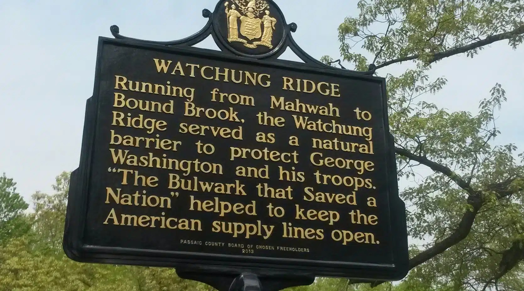
“The Revolution’s most formidable natural bulwark.” Cunningham also described the two principal Watchung ridges as being: “Like the outer walls of a tremendous fortress.” The marker is in Woodland Park, New Jersey, in Passaic County
New Jersey became the Cockpit of the American Revolution because armies repeatedly crossed and contested it. But Washington endured inside that cockpit because the Watchung Mountains gave him something the British never fully overcame: a geological fortress.

After all our work….. We Found This
After all our work… we found this video gem!!! If you have time, here’s a great video that also substantiates Washington’s Geological Fortress and how it helped Washington win the Revolutionary War.
Dr. Michael Beck’s video, “How Central New Jersey Won the Revolutionary War,” discusses the Watchung Mountains, the fortress that helped the United States ward off British campaigns. The book (see below) appears to be self-published.

Beck describes himself as an amateur historian affiliated with the Somerset County Historical Society. The book is available directly from the Somerset County Historical Society. Contact the Society and send a check for $15 plus $6 postage if you would like to order a copy via mail. Please remember to include a return mailing address. Somerset County Historical Society -Van Veghten House
9 Van Veghten Drive, Bridgewater, NJ 08807 Phone: 908-218-1281 Email: info@somersethistorynj.org

Related Research
Meet Herb Patulo
A Man Who Honored Washington’s Geological Fortress and Lived it…..


