
Certainly, everyone knows when they’re in Peapack and when they’re in Gladstone, right?

First off, a little clarification: the “Established 1701” on the borough’s sign date refers to the Peapack Patent, when the land encompassing present-day Peapack-Gladstone was granted to European proprietors. It marks the area’s colonial land history, not the borough’s incorporation, which occurred in 1912. Peapack is believed to come from the Lenape word Peapackton, meaning “marriage of the waters,” while Gladstone was named for British Prime Minister William Ewart Gladstone.

Many may not know, but Peapack and Gladstone were originally part of Bedminster, New Jersey. Yes, if you go back to 1749, a Royal Charter was issued by Royal Governor Jonathan Belcher, and later by King George II, officially recognizing the Township of Bedminster, which included the villages to the north that later became known as the Borough of Peapack and Gladstone.

Peapack is the older of the two village names and reaches back to the area’s Lenape presence. The name was already being used when the Peapack Patent was issued to George Willocks and John Johnstone in 1701, and a 1708 deed specifically mentioned an Indigenous settlement called “Peapock” or “Pepock.” The familiar translation “marriage of the waters” refers to the meeting of Peapack Brook and the North Branch of the Raritan River, although the precise Lenape derivation is uncertain. An early language authority suggested that it may instead have meant “by the waters” or described a pond or water within marshy ground. What is certain is that European settlers inherited the name from the Indigenous landscape rather than inventing it.

Gladstone, by contrast, is a much newer name. The northern settlement had been known locally as Upper Peapack when an application was made in 1886 to establish a separate post office called Gladstone. Local tradition credits landowner William Hillard with proposing the name in honor of William Ewart Gladstone, the internationally famous British statesman admired for his support of representative government and political reform. No evidence shows Gladstone ever visited the Somerset Hills; it was simply a Victorian-era tribute to a prominent living political figure. The railroad reached the already-named village in 1890 and made Gladstone its western terminus, further cementing the identity before Peapack and Gladstone joined to form one borough in 1912.
Sooooo…Where Does Peapack End and Gladstone Begin?
For more than a century, people have lived in either Peapack or Gladstone, but remarkably few can explain exactly where one village ends and the other begins. There is no welcoming sign along Main Street, no painted line across the pavement, and no separate municipal boundary shown on the borough’s tax maps. That is because, legally, the line does not exist. Let that sink in.
Assembly Bill No. 483
Peapack and Gladstone were already recognized as Bedminster’s two neighboring villages when residents of both villages voted to separate from Bedminster Township. As with most succession petitions of the time, Peapack and Gladstone residents wanted their taxes spent on the modern services their villages needed, and independence gave them that authority.

The villages petitioned the New Jersey Legislature to create a new Borough. The enabling legislation, identified locally as Assembly Bill No. 483, was approved in March 1912 and signed by Governor Woodrow Wilson. The proposal then went before local voters on April 23, 1912, and its approval officially created the Borough of Peapack and Gladstone from part of Bedminster Township. They became one municipality containing two established villages, not two separate boroughs. After passing, the bill was noted as Chapter 244, Laws of New Jersey, 1912
Approved March 28, 1912

The combined area had already been designated Bedminster Township Lighting District No. 1 on June 6, 1905. When the Borough was created seven years later, the 1912 incorporation act specifically adopted the exact boundary of that existing lighting district. In other words, the petitioners did not invent a new territory; they essentially converted an established municipal service district into an independent borough.

The two villages acted together and became one municipality: the Borough of Peapack and Gladstone. The incorporation established the borough’s outer boundary, but strangely, it did not survey or create an internal boundary between the two villages. Today, every property in either village is legally located in the same borough.
Still, the names Peapack and Gladstone never disappeared. Each village retained its own railroad station, post office, and sense of identity. Over time, the postal system became the most practical way of determining which village an address belonged to. Peapack addresses generally use ZIP Code 07977, while Gladstone addresses use 07934. The two post offices remain tangible reminders of that distinction: the Peapack Post Office is located at 155 Main Street, while the Gladstone Post Office stands farther north at 266 Main Street.

However, it is important to understand what this line represents. It is not a political, legal, or separately governed village boundary. It is primarily a postal division that gradually became the accepted local definition of the two villages. A deed, tax record, or municipal document properly identifies every property as being in the Borough of Peapack and Gladstone. “Peapack” or “Gladstone” describes the traditional village and postal address.

“Even Santa Claus doesn’t know of a boundary between Peapack and Gladstone.”
Local resident….
So, after more than a century of uncertainty, the answer is this: Peapack and Gladstone have no official legal boundary, but on Main Street, we bet locals have an opinion on this. What are the options, or does someone know something else?
Wait….There Has to Be an Answer
So here’s where we are historically. Nothing official identifies the actual village boundaries between Peapack and Gladstone Villages. But you know if you live there, residents have an opinion on what village they live in, right? Let’s say that you live in the Borough of Peapack or Gladstone. Obviously, if you live in Peapack or Gladstone, you represent your village. Realtors have to know, right? If it’s not official, there has to be an unofficial answer to this important local question. Let’s go through a few options.
Possible Option 1: Zip Codes Define Village Boundaries
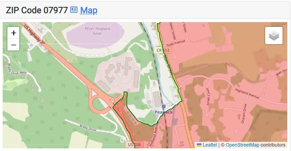
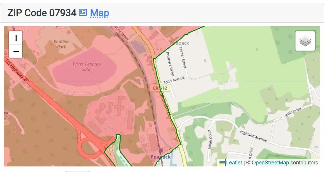
The simplest answer comes from the Postal Service: Gladstone is ZIP Code 07934, while Peapack is 07977. Each village has its own post office and mailing identity, even though both belong to the same Borough of Peapack and Gladstone. ZIP Codes were introduced nationwide on July 1, 1963. ZIP means Zone Improvement Plan. The shared 079 places both communities within the same regional sorting area, while 34 identifies Gladstone and 77 identifies Peapack. The numbers have no historical meaning; they were created to sort and deliver mail.
The names are much older. Peapack comes from a Lenape term traditionally interpreted as “the marriage of the waters,” while Gladstone honors British Prime Minister William Ewart Gladstone. The two established villages joined in 1912 to form one borough. The ZIP Codes offer a practical dividing line, but not an official one. Postal areas follow mailing routes, not legal village boundaries.

Possible Option 2: Railroad Stations
We began with the most important historical fact: Peapack and Gladstone are not two separate municipalities with a legally surveyed boundary between them. They are two historic villages that have shared one borough government since 1912. That meant there was no official line on a municipal map to trace.


Possible Option 3: Tiger’s Corner and St. Lukes
The clearest change in Main Street addresses appears near Tigers Corner at St. Luke’s Avenue. An address at 176 Main Street is identified as Peapack, while St. Luke’s Church at 182 Main Street is identified as Gladstone. This unusually close change makes Tigers Corner the most defensible location for the proposed village divider to cross Main Street.


From that point, we extended a presumptive line across the borough to illustrate the traditional relationship between the two village centers. It should not be understood as a legal boundary or an exact ZIP code border; some parts of the borough even use a Far Hills mailing address. Instead, the line is a historically informed interpretation based on postal usage, recognized landmarks, transportation centers, and how the two villages developed alongside one another.
Possible Option 4: Landowners Decided
Our fourth option adds an important historical layer through land ownership, but it should be treated as supporting evidence rather than proof of a boundary.
By 1912, several enormous estates were shaping the two village centers. C. Ledyard Blair’s Blairsden was closely identified with Peapack, while Walter and Kate Macy Ladd’s Natirar occupied land around the Peapack side and extended into neighboring municipalities. To the north, James Cox Brady began assembling Hamilton Farm in 1911, an estate firmly associated with Gladstone. These families, their employees, and their visitors generally depended upon the nearest railroad station, post office, shops, and churches, strengthening the separate identities of the two villages. Blairsden history, Hamilton Farm history, Natirar history

The large estates therefore help explain why Peapack and Gladstone felt like distinct communities even after they became one borough. However, estate boundaries were irregular, changed over time, and sometimes crossed municipal lines. We can use those properties to reinforce the presumed divider, but we should not claim that a Blair, Ladd, or Brady property line officially separated the villages. Establishing that would require comparing the map with a landowner or tax map from approximately 1900–1912.
What Do You Think?
Where do you think the boundary is between Gladstone and Peapack?
Tell Us Below:
Submitted Results so far:
Tell Us Your Thoughts…


