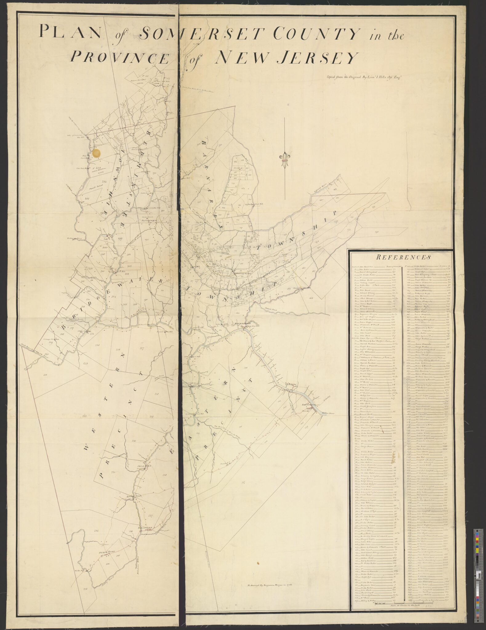
The 1766 Morgan–Hills Map of Somerset County
Unlike most eighteenth-century maps that depict only towns and transportation routes, the Morgan–Hills map provides a remarkable snapshot of the county’s agricultural landscape by assigning numbered tracts to individual owners in an accompanying reference index. It captures the farms and estates of many of the families who shaped the region, including the Harrisons, Alexanders, Annins, Parkers, Southards, Lewises, Ayers, and numerous others whose descendants played important roles in the settlement and development of Basking Ridge and the surrounding Somerset Hills.
Today, the map serves as an invaluable resource for historians, genealogists, archaeologists, and local researchers. By comparing its parcel boundaries with modern roads, deeds, and historic sites, researchers can reconstruct the colonial landscape and better understand where many of New Jersey’s Revolutionary War events—including those associated with General Charles Lee, Widow White’s Tavern, Lord Stirling, and the founding families of Basking Ridge—took place.

Surveyed by Benjamin Morgan in 1766 and later copied by Lieutenant John Hills, Assistant Engineer in the British Army, the Plan of Somerset County in the Province of New Jersey is one of the most important surviving maps of colonial New Jersey. Created a decade before the Declaration of Independence, the map documents Somerset County as it existed on the eve of the American Revolution, identifying hundreds of individual landowners, property boundaries, roads, rivers, churches, mills, and other significant landmarks.
The original 1766 Morgan–Hills Plan of Somerset County was drawn on two manuscript sheets measuring 158 × 113.5 cm (approximately 62.2 × 44.7 inches), making it one of the largest and most detailed surviving colonial maps of New Jersey.
Scale: 50 Chains to an Inch — A surveyor’s chain measured 66 feet. Therefore, 50 chains = 3,300 feet (5/8 mile), meaning every inch on the map represents approximately 0.625 mile on the ground.
Plan of Somerset County in the province of New Jersey: Copied from the original by Lieut. I. Hills, asst. engr. / survey’d by Benjamin Morgan in 1766.
Observations
Assuming your normalized totals and using the current land area of Somerset County, New Jersey (301.87 square miles, approximately 193,197 acres) for comparison, here is the revised ranking of the Top 15 landowners back in 1766. (Census.gov)

| Rank | Landowner | Total Acres | % of Present-Day Somerset County* |
|---|---|---|---|
| 1 | Peter Sonman | 41,600 | 21.53% |
| 2 | John Harrison | 18,100 | 9.37% |
| 3 | William Penn (combined) | 13,000 | 6.73% |
| 4 | Alexander & Dunster | 6,724 | 3.48% |
| 5 | Campbel & Blackwood | 5,970 | 3.09% |
| 6 | Wm. Dockwraes | 5,000 | 2.59% |
| 7 | Tho. Harts | 4,000 | 2.07% |
| 8 | Charles Dunster | 3,500 | 1.81% |
| 9 | Sir Ewen Cameron | 3,000 | 1.55% |
| 10 | Tho. Barker | 3,000 | 1.55% |
| 11 | Lord Neil Campbell | 2,650 | 1.37% |
| 12 | James Alexander | 2,457 | 1.27% |
| 13 | Peter Sonmans | 2,000 | 1.04% |
| 14 | Tho. Cooper | 2,000 | 1.04% |
| 15 | Clament Plumstead | 2,000 | 1.04% |
Note: Our comparison is based on Somerset County’s current land area (301.87 square miles, or approximately 193,197 acres). (Census.gov) compared to the data found on this 1766 map:
- Peter Sonman controlled over one-fifth of the land area of present-day Somerset County.
- The Harrison family, when John Harrison and John Harrisons are combined, held 18,100 acres—nearly 10% of today’s Somerset County.
- William Penn’s proprietary lands, combining both Penn entries, totaled approximately 13,000 acres, or 6.7% of the county.
- The top three owners alone controlled approximately 72,700 acres, equal to 37.6% of the land area of present-day Somerset County. (Census.gov)
This striking statistic helps readers appreciate the scale of these colonial land grants.
Basking Ridge Detail and the Widow White’s Tavern
“Although Samuel Brown owned the 106-acre farm by the early eighteenth century and died owning it in 1763, the 1766 Morgan–Hills map appears to label the surrounding tract under an earlier proprietary owner rather than the farm’s contemporary occupant. This reflects the map’s function as a proprietary land survey rather than a current ownership atlas.”

The Basking Ridge Presbyterian Church is No. 153.
Middlebrook Encampment (Bridgewater) Rev War (Washington Campground Association)

| No. | Landowner | Acres | 1766 Township (UNDER REVIEW) | Hamlet/Town (Today) WIP |
| 20 | Heirs of Huppser | 100 | Bridgewater | Middlebrook |
| 25 | Morris & Alexander | 39 | Bridgewater | Middlebrook |
| 26 | John Cusart | 20 | Bridgewater | Middlebrook |
| 27 | John Steele | 57 | Bridgewater | Middlebrook |
| 28 | Isaac Dye | 50 | Bridgewater | Middlebrook |
| 29 | Isaac Dye | 50 | Bridgewater | Middlebrook |
| 30 | Isaac Dye | 50 | Bridgewater | Middlebrook |
| 31 | Tho. Erwin & Dan. Blackford | 40 | Bridgewater | Middlebrook |
| 32 | Azeriah Dunham | 41 5/10 | Bridgewater | Middlebrook |
| 33 | Joseph Ross | 100 | Bridgewater | Middlebrook |
| 34 | Laffiert Selring | 34 | Bridgewater | Middlebrook |
| 35 | Peter Williamson | 37 | Bridgewater | Middlebrook |
| 36 | Wm. Farquar | Bridgewater | Middlebrook | |
| 37 | P. Williamson & C. Addoms | 60 | Bridgewater | Middlebrook |
| 38 | Addoms & Erwin | 100 | Bridgewater | Middlebrook |
| 39 | Azeriah Dunham | 22 | Bridgewater | Middlebrook |
| 40 | Morris & Alexander | 50 | Bridgewater | Middlebrook |
| 41 | Joseph Ross | 62 8/10 | Bridgewater | Middlebrook |
| 42 | Joseph Colter | 20 | Bridgewater | Middlebrook |
| 43 | David Cusart | 100 | Bridgewater | Middlebrook |
| 52 | Morris & Alexander | 347 | Bridgewater | Middlebrook |
| 56 | Bridgewater | Middlebrook |
Marking Up The Map To Show Today’s Reference
The map and list below were developed with MLHP researchers to help fellow researchers identify landowners shown on Benjamin Morgan’s 1766 map of Somerset County and to connect those colonial properties to the people, places, and Revolutionary War stories that shaped Somerset County, New Jersey.
Using GIS software, the map was deconstructed and tagged to a map from today that lets us identify boundaries, streets, and structures so to understand who was the owner of the land back in 1766.
Note:
If you need to read the numbers on the map, it’s best to download this image, as the enlargement blurs them. Click image to enlarge.
Also, the working index below is designed to assist researchers in connecting the above 1766 Morgan–Hills map with the founding families in Somerset County, related to Mr. Local History research, and the Revolutionary War events that unfolded across these historic farms. We’ve also tried to put township boundaries today for further reference.
Please note that the spreadsheet below is for reference only, and the data may require further interpretation as our researchers evaluate and update. So it is evolving……