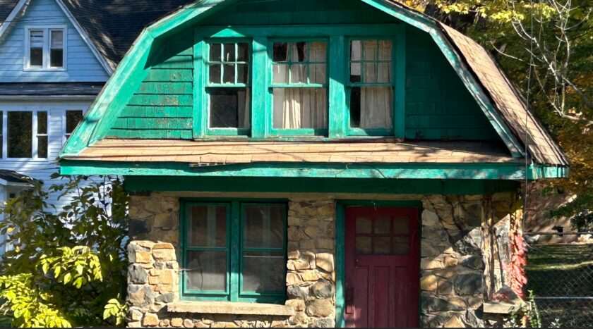
As with all Mr. Local History retrospectives, we often update the post when we learn stories and are sent photos from our community. We will continue to expand this piece as information becomes available. If you have any stories to share, please post in the comments section at the end of the piece.
Mr. Local History Project
UPDATE MARCH 15, 2025:
Well, the research has finally paid off as we have the answer.
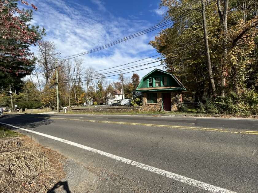
What has been called out as a “weatherbeaten shed, with a stone wall, and a two-story two-room building close to the roadside” has been identified. As we learned that Highland Farm was being sold off, part of Rogers Highland Farm was purchased by a group that founded the Freedom Hill Society, a socialist community founded in 1918 by the I.L G.W.U. The “I.L.G.W.U.” refers to the International Ladies’ Garment Workers’ Union , founded in 1900, a historically significant labor union that represented workers in the women’s clothing industry in the United States and Canada. Local 89 of the International Ladies’ Garment Workers Union (ILGWU) was chartered in 1919 and based in New York City. The society was also referred to as the Freedom Hill Summer Society. The “shed” actually bore the name name “Freedom Hill General Store.”
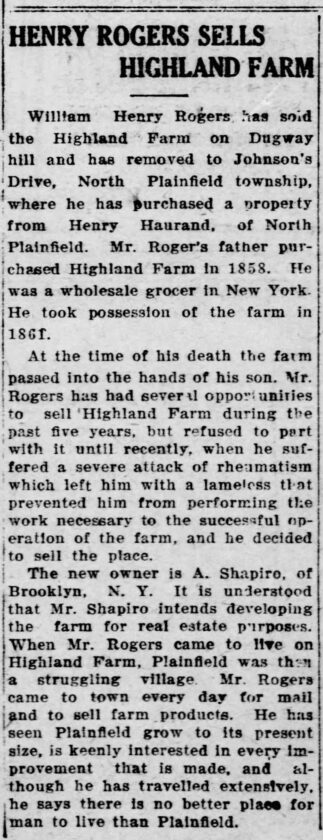
The small green and stone two-story structure at 32 Hillcrest Road was also used as a real estate office, and the larger house behind was an educational center and a meeting house for the society. Five additional cottages on the property served as summer accommodations for visitors. The Freedom Hill Association was formed by 35 families in July 1918. A key organizer was Sebastian Liberty, born as Sebastian Liberescu, a Jewish refugee whose family immigrated from Jassy, Romania. The property was purchased from the Rogers family who had owned Highland Farm on what was then called the top of Dugway Hill. This community was part of the labor movement’s efforts to provide workers with alternative living arrangements during the early 20th century. “Freedom Hill is known as the eldest daughter of Free Acres,” another society formed to the east along Emerson Lane in Berkeley Heights.
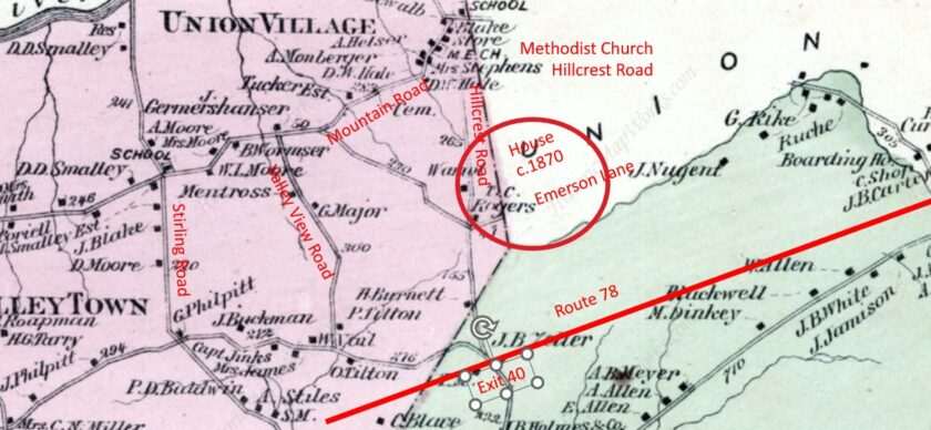
Thank you, everyone, for sharing your research and clues with us on Facebook and via our Contact Us form. A few clues have come forward. First, the terms Stony Hill and Dugway Hill provide more clues about the area, leading us to find two farms: Rogers Farm down Dugway Hill and Highland Farm, owned by T.C. Rogers, as noted on an 1873 map. Deed records also show information tied to the Rogers Tract of land, so there are ties here.
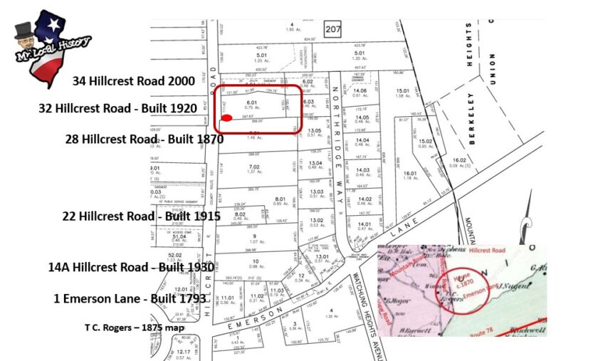
But the house we found on the corner of Hillcrest and Emerson Lane tells us that is where Highland Farm was—and it was a big farm. According to records, that house was built in 1793, with nearby houses built in the 1870s and 1920s. The names Drake and Rogers keep appearing in area searches and old maps. We now think the Green Gatehouse has something to do with Highland Farm. Read the two stories we’ve found, and stay tuned. We’ll keep digging.

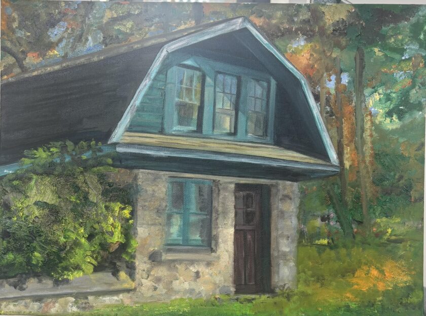
Our research continues, and we hope you write us if you learn anything. Wanted to share as a FBer posted this beautiful art rendering after seeing our photos. Thank you, Gail Friedman Schoenbach for your beautiful piece.
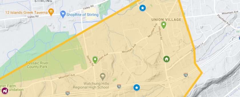
Here’s what we’ve heard so far from the public about the tiny green house on Hillcrest Road in Warren:
It was an estate gatehouse. It was a general store. It once sold gas. It was once home to the Sewing Union. It was part of a Jewish camp….. the clues keep coming!
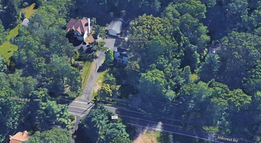
Just south of the hamlet of Union Village in the eastern section of Warren Township sits a tiny house on the northern side of the road. The 32 Hillcrest Road structure has interested passersby for years as it certainly isn’t a regular residence; it’s built at the end of a stone wall and seems out of place. So what was it? Who built it?
The Mr. Local History Project read a Warren Township Facebook group post asking if anyone knew the cottage’s history. Looked like a perfect challenge for MLHP.
Warren Township (Somerset County) History
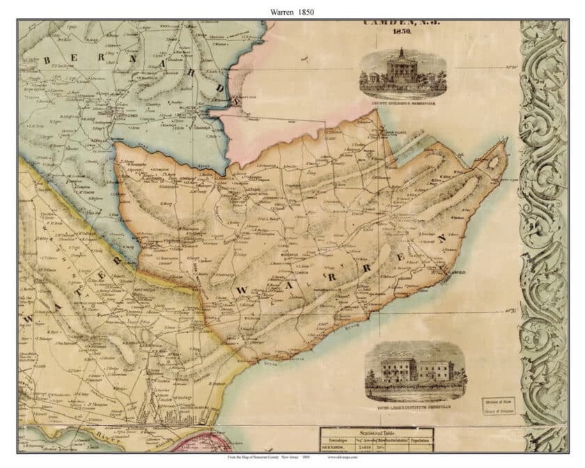
Warren Township, Somerset County, New Jersey, was formed on March 5, 1806, from the previously existing Bernards Township, formed in 1760 by Royal Charter. In 1806, Warren included the separate towns of Green Brook, North Plainfield, and Watchung. The present township contains almost 20 square miles.
The area’s noted 3,000-acre tract was initially purchased by William Docwra in 1690. Warren Township was officially recognized in 1806, separate from Bridgewater and Bernards Township. Later, North Plainfield, Watchung, and Green Brook would separate, leaving Warren as it is today. The present township contains almost 20 square miles. Villages in various parts of the municipality include Mt. Horeb, Springdale, Mt. Bethel, Smalleytown, Union Village, South Stirling, and Warrenville. The township is named after Bunker Hills’ noted hero, Joseph Warren, who died on that hill on June 17, 1775; he embodies the young nation’s sacrifice.
The sleepy township stood quiet until the construction of Route 78 was carved through the township in the 1970s. Since the early 1700s, the area was a rural farming community that later in the 20th century drew a large contingency of German Jewish farmers who escaped WW2 in Europe looking to start new, simpler lives. The space became a country retreat, much like the nearby Catskills, catering to families from New York City looking for a weekend in the cooler temperature and spacious New Jersey countryside. In 1982, there were still 150 working farms in Warren, but now almost all are victims of the very charm of the surroundings that have attracted many newcomers.
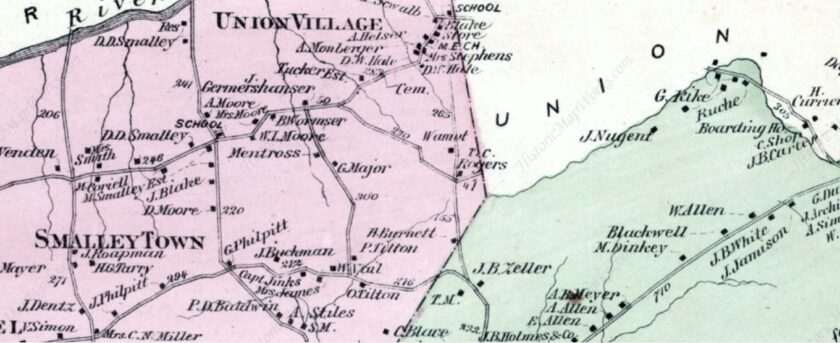
In the Union Village area of eastern Warren in the 1850s, the Union Village Methodist Episcopal Church, now known as the Union Village United Methodist Church, was the most prominent church in the eastern Union Village area of Warren Township, New Jersey. Established in 1789, it was one of the oldest religious institutions in the region and served as a central hub for the local community. Reflecting the predominantly Methodist population of the time, the church played a significant role in the area’s spiritual and social life. Located near the crossroads of what is now Mountain Avenue and Hillcrest Road, it stood as a key landmark in eastern Union-Village, embodying the community’s deep-rooted religious and historical heritage.
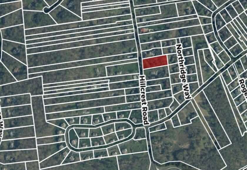
Hillcrest Road in the 1820s was known as “Dug Way Road.” The name still exists as Dug Way South on Hillcrest Road in Watchung. The property is now known as Block 207, lot 6.01, in the Union Village section of Warren Township, New Jersey. It wasn’t until 1878 that the train arrived in Stirling, just to the north, and the population remained steady over the early 1900s. In 1875, the population of Warren was only 1,097 and declined to 1,083 in 1920. It was post-WW2 that showed tremendous growth with a post-war housing boom.
The Property – Troubled Past
Our search starts at 28 Hillcrest Road, Block 207, Lot 7.01. MLH went on a deed search at the Somerset County records office and dug through several deed books researching the property. If you’ve ever done a deed search, the biggest obstacle is reading the handwriting in the deed books. We returned to 1868 when we located the Hillcrest Road record that the ” Isaac V. Brower Homestead” was purchased for $200 on March 30, 1868.
We then fast-forward to February 5, 1909, when the Somerset County records noted that Sheriff Frank T. Ross deeded the property for $995 to William Mirnaugh.
In the late 1930s, on August 2, 1939, the property was sold again at a Sheriff’s sale. Thomas C. Vail, Sheriff of Somerset County, sold the property with the gatehouse to Liberty Building & Loan Association of Plainfield for $2,706.82. The property was foreclosed from Sebastian and Rose Liberty on Feb 10, 1928. The neighboring plot’s previous owner, Samuel Most, mentions a map, “Map of Rogers Tract” Stony Hill (c1914) Plot #1 in Union and Somerset Counties. Shown on the map as Plot #4 in August 1914.
Again, on December 12, 1944, Liberty Building Supply sold and liquidated the property to Empire Mortgage Liquidation. So, we returned home to analyze the data and see what we could find.
After five hours of research and we came up empty.
Brooks Betz, MLHP researcher
So I’m putting it down for a bit. We won’t give up!
Research Clues and Facebook “Crowdsourcing” for more Clues
We always like reaching out to the public to see what we can find. It’s called “crowdsourcing.” We have a few clues we’re working on:
- While the property has divided over the years, there remains a wall that encompasses multiple property addresses with an entrance break for vehicles, and an entrance break for pedestrians.
- The gatehouse is attached to this wall, stating that it was once part of this walled property front.
- The gatehouse fits the late 1800s or early 1900s architecture, typically where rocks have been excavated on a tilled property, where the rocks are then reused.
- There is a mention that the house at 28 Hillcrest was initially built in 1870, hence another clue.
- 1899 – Robert Rogers, son of William Rogers and grandson of Thomas C. Rogers, who owned the house on the corner of Dugway and Emerson Lane, of the Highland Farm family, married Clementina Burgmiller, who lived next door on the Burgmiller Farm.
We’ve been reviewing Facebook clues from a published post to help with our search and see what any neighbors, residents, or history fans might know. Here’s what they’ve said:
- It looks similar to the gatehouses of “Castle Tract” in Watchung. There are two? In North Plainfield, that was by the Castle roadways up the hill. It seems like it could have acted similarly to something more significant in Warren.
- Harris Ruben – There was a gatehouse to the old Hicks Farm on Old Farm Road. I don’t know how big the farm was or if it had another entrance on Hillcrest (which my parents called “the dugway” back in the 1940s.
- Grete Terjesen—I grew up in Berkeley Heights. We moved there in 1964. Once we got our driver’s license, we would explore along Hillcrest Road. At that time, people were living in that gatehouse. Up along the dirt road on the left of the gatehouse, there was a large commune with a lot of interesting individuals coming in and out.
- Michael Pavlov – My friend Mike said that in the early 1960s, a gas pump was right by the road. You could get fuel there, and there was a small store inside.
- Susan Sage – My father said that in the 1940s and 1950s, it was a general store selling household items.
- Tilda Munier—The previous owner, Frank Decorato, said it had something to do with the first headquarters of the sewing union. I lived across the street for 38 years. Frank and his wife Doris passed years ago. I don’t know if this is correct, but he lived in the house during the summer and in Manhattan the rest of the time. If someone finds out something different, I would love to know.
- Ray Reu—I grew up on Hillcrest Road (born 1970). This is not a general store, as it would be more prominent, like the house on Emerson Lane, on the corner of Beechwood Road. I recall a rock wall around the front and a large house behind it. It’s meant to look like a gatehouse or a caretaker’s home from the early 1900s. That was done a lot in this area, especially as you get into the hills of Bedminster and surrounding the great swamp.
- Daniel Gallic—We bought our first house a few doors down about 25 years ago. Back then, you could look in the windows and see products on shelves like a general store. The property was bought and sold a couple of times.
Warren’s Historian
The MLH Project interviewed author and Warren’s local historian Alan Siegel about the gatehouse at the 32 Hillcrest Road property.
In the 1920s and 30s, the site was once a Jewish summer camp. The break in the wall was the driveway entrance to the camp.
Alan A. Siegel, Warren local historian and author mention the property briefly in his book Warren A to Z.
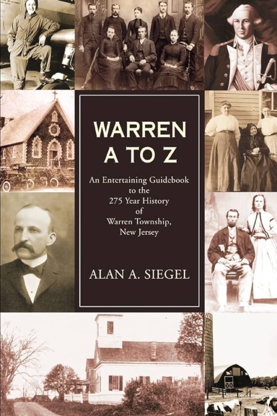
Also, look at the history of Camp Harmony in nearby Mt. Bethel in Warren, which is a similar tale.
Side Story – Free Acres
We love it when one story’s research leads to another. Just east of the Gatehouse on Hillcrest Road is the area known as Free Acres. The 75-acre wooded community of 85 households is just to the east on the property next to the Warren gatehouse. Among the early residents of Free Acres were author Thorne Smith and his wife, Celia, and actor James Cagney and his wife, Billie. Learn more about Free Acres and see pictures.
We have learned from Free Acres that this structure is not and has never been part of the Free Acres homestead.
Maps Used for Our Research
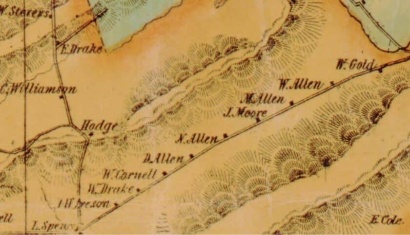
- Somerset County Map including Warren – c1850
- Landowners–New Jersey–Somerset County–Maps c1850
- Warren and North Plainfield Map c.1873 – Published by F. W. Beers in 1873
Their is a similiar structure across from high school and cianellia property. I do not know if its still their. Look for Linda Apgar about 72 yrs old she lived in that house for awhile.
Thank you for sharing article.
I grew up in Berkeley Heights. We moved there in 1964. Once we got our drivers license, we would explore along Hillcrest Road. People were living in that gate house at that time. Up along the dirt road on the left of the gate house, there was a large commune with a lot of interesting individuals coming in and out.